

A bit of a forgotten gem this location, Gilmour’s Linn up Touch Glen near Cambusbarron. There is not very much information online about this place but it is a stunning location if you know how to find it. Unfortunately ( or maybe fortunately?) even with a map it can be hard to find. I have been there 4 times now over the last 10 years or so and still make mistakes each time I go.
A wee bit on pronunciation. “Touch” isn’t said in the same way as “touching an object”, the best starting point is the word “Took” which is near as dammit there. If you are Scottish rolling the “ch” sound won’t be a problem! if you aren’t Scottish, the “ch” is kind of said like you were trying to clear your throat!
About the cave
Legend has it that the cave was used by Charles Edward Stuart while in hiding from British Forces following the failed Jacobite Rebellion in 1745. How he came to be in the area of Stirling I am not so sure, presumably, this would have been on the retreat from the abortive advance towards London that ended in disarray. He is known to have visited the village and camped his army on local fields earlier in the campaign. I have also read it was after the Jacobite army was defeated and spread in disarray following the Battle of Culloden Moor. See Page 3 of A Cambusbarron Tapestry by Peter Paterson.
Talk about snatching defeat from the jaws of victory?
Whatever the truth, one imagines coming anywhere near Stirling then was a risky business it being a garrison town overlooked by the mighty Stirling Castle, but the River Forth would need to be crossed somewhere safe on the way northwards. To have found the cave local help would almost certainly have been needed.
Spending any time holed up there must have been a miserable experience as it’s not what you could call dry. There are constant drips of water raining down inside from the waterfall, and maybe seeping through the rock above. However, it makes for an enchanting spot.
The glen runs pretty much South West to North East and the Cave faces Northward so light here is rarely more than adequate even on bright days.
Finding the Cave and Waterfall
The first thing to know is while it isn’t a really long walk, under an hour by whatever route you choose, it has its challenges. There are some steep sections. Also be aware that if there has been much rainfall prior to a walk, the ground will be even wetter and slippier than normal and actually accessing the cave might require you to get wet feet if the burn is up.
I strongly recommend good walking boots and walking poles for stability and balance in some locations.
The Direct shorter route
(red on the Google Map)
Most things I have read of the route to the cave discuss coming from the old waterworks by Touch Hills Reservoirs. As the crow flies it is shorter but the ground is lumpy and it can be a bit hard going, though reasonably flat for the most part.
Certainly, my first three visits were this way but the last time I did this, a huge deer fence had been erected and actually getting into the Glen was pretty difficult. Not impossible but difficult. To go this way park near the cottages by the waterworks, (make sure you aren’t blocking entrances or peoples homes) and head across the boggy ground to the west past the old Scout Hut. Keep heading west you will come to a house, detour around the south of this and keep heading west. You can barely fail to come to the deer fence. The going is pretty wet in places. Do not wander off up the slope to your south (you’re left as you head in).
There are a few walls and fences you need to cross. Also, sheep roam free here, so if you have a dog they need to be on a lead. Actually, if you have a dog, I have no idea how you will get it over the deer fences! As you near the glen you will hear the sound of the waterfalls all the way up the ravine.
How you negotiate the deer fence is your business but you will now need to get down the very steep slope into the Glen and locate the old, very rickety “bridge” over the Touch Burn. Last time I came this way you really were taking your life in your hands crossing here as it was so wet and rotten. You do though need to get yourself over to the West side of the glen. From there keep following the glen south. You will come past several waterfalls on the way and if you have never been here before likely you will want to take a look as they are all very scenic in their own right. Some, however, are dead ends and you will need to backtrack out and go round the intervening land as you work your way south. Unless you are seriously into “canyoning” or “Gorge walking” and are equipped with wetsuits, ropes and helmets, do not even try to stay with the burn all the way up.
Nearing the head of the glen you need to get onto the higher ground to the west for a bit and away from the ravine but don’t worry, the ground does steer you back towards your ultimate destination the walk through the trees ( you will be inside a deer fence on the west side of the glen at this point- no need to cross this one). At this point you will see the section of fence mentioned in the alternate route I discuss below. So read on to the final leg.
The alternate ( I think easier) route.
( yellow on the Google map)
The way I went on this most recent visit was I felt MUCH easier. However, there are some caveats. If your sole intent is to reach the cave at the top of the glen this is the way to go. If however you are inclined to detour over the deer fence and down to the burn in the lower glen some of the slopes can be challenging and but you will no doubt see the bridge mentioned above and should follow the instructions from there.
Finding a starting point
So bypassing detours, this way is fairly direct and for about 2/3’s of the way is an easy to follow trail.
From the West end of Touch Road
Assuming you come by car you will want to park somewhere, you can either park at the entrance to the forest at Garshellach Forest and walk back along the Touch Road towards Cambusbarron about half a mile. Watch though there are a series of blind bends here and cars have a tendency to come round quite quickly, so have your wits about you when walking here. People won’t expect walkers on the road here. After the series of initial bends you will pass an old rather run down looking cottage on the right that has a lot of old wood outside, keep going right past this. Round the next bend there is a short straight and another cottage on the right, once again you should pass this by as it is private property.
Once passed this cottage the open field to your right over about 20 metres of some fairly uneven ground that borders the road, is in essence where you are heading for. On an OS Map you want to be at Grid Ref OS Grid Ref: NS 75170 93248
From the East End of Touch Road
You could park in Cambusbarron village and walk out on the top road ( Touch Road) – around three quarters of a mile or so, walk out past the entrance to Touch Business Park and keep going.
When you come to where the road crosses the Touch Burn on a bend ( there is a fairly obvious small bridge) you will be looking to get into the field on the left. But you are best to access from further along the road.
Just about this point past the bridge there is a third option for parking) locate the disused looking field entrance on the North side of the road along the way, and if you have a suitable vehicle that has enough ground clearance and won’t get stuck ( yes a 4×4) you could park in towards the rather knackered rusty looking old gate. I have never seen this gate used.
From this spot there is a cabin style house on the south side of the road and an access track that winds up towards a rather splendid looking yellow house behind. UPDATE: During 2020 there was a pair of rather large metal gates installed at this entrance. Clearly, someone isn’t happy with people accessing through here. They aren’t always closed, definitely do not drive through here. Walk past this gate, staying on Touch Road until you turn a slight bend in the road. On your left there should be a field visible to you through the thinner trees here. The Grid Reference is OS Grid Ref: NS 75170 93248. Cross the rough ground between the road and the field and you should see a gate into the field. Head for that then follow the track up the field heading roughly south parallel to Touch Glen which will now be on your left.
Beware, on one walk I encountered a seriously annoyed Bull in this field and had to make a careful retreat!
You should see a track meander up the field. Stay on the track all the way up and you will come to a big gate in the deer fence. Pass through here closing the gate behind and keep following the trail, it is quite easy to follow. If you encounter a fork in the trail up here, stay left towards the glen you will be by now aware of on your left. Keep going all the way until you reach the end of the trail. Here you need to enter some woods. ( fairly thin ones). Keep the deer fence to your near left using it as a guide until you eventually come to a point where you will feel quite high above the glen but there is a section of deer fence that turns sharply left for one span with a wooden section at the top.
I would say this is the easiest bit to get over.
The final Leg
Common to both routes
Once on the inside of the deer fence keep heading south but head towards the glen through the light trees and bushes until you see the waterfall just below/ahead and look for the zig zag route down into the glen. There were some old bits of broken fence and wire here.
You will need to duck under trees or negotiate thorn bushes to get to where the burn enters from the right. The cave now is directly in front of you with the waterfalls above. You may get wet feet crossing the burn if it is swollen by rain. Take care not to fall or twist an ankle here, you would have a lot of problems getting out of the glen on a bad injury. Note, I had pretty good EE 4G coverage all the way in here.
Photography
On my most recent trek here (February 2018), I had with me for the first time my DSLR, tripod, some filters and a wide angle lens. Apart from the nuisance of carrying them all in a Lowepro Slingpack ( which is great but not for this kind of outing) , the biggest issue on location was water dripping from the cave. I was aware of it when I stood under the overhang but didn’t think it was hitting my filter as I couldn’t see it though the viewfinder. However, there were a few water spots when I got back and examined them in post processing.
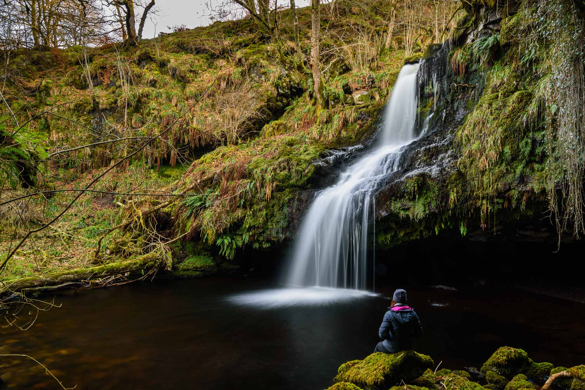
The cave and waterfall at Gilmours Linn in Touch Glen
I took a few shots but the one I was most pleased with was the one with my good lady wife sitting on a rock looking at the waterfall and pool. I think it gives the sense of scale to this spot. You can also just see the late afternoon sun was clipping the trees high above. At this time of year that’s about as much light down here as you can expect. To ensure a long enough exposure I used a 2 stop ND filter, a two stop soft grad to reduce the bright light from the sky and a Polarising filter to reduce reflections.
This was a long exposure at ISO100, 14mm and f11.0 for 8 seconds. Mrs H had to sit very still!
I will maybe try to get back in the mid summertime to see if a sunset catches the cave at all. Photo Pills suggests it does. Next time I will bring a rucksack and some hiking poles.